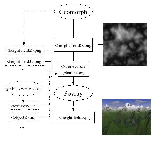
How
Geomorph launches Povray
When the Geomorph user clicks on the "Render" button

, a command like
this one is executed:
povray +I
scene.pov +O
_hfname.png +P + D +FN +W480
+H640
This command can also be executed on the command line, in a Linux
console.
Before launching the command, Geomorph saves the active document in the
"test.png" file. The Povray templates use this name as input. This way,
you can render the active height field to see the outcome of what you
are doing, before saving it under its actual name, in case you want to
cancel the last change.
Version 0.40 and later
Now the
active document name is contained in the global variable main_terrain. It is "test.png" if
the active document has unsaved modifications, or the document name if
it has been saved.
|
Geomorph also saves the parameters of the current camera in the
camera.inc file.
The meaning of the options are:
+I : Input scene, the *.pov text file you can edit.
+O : Output file, a PNG or a TGA.
+FN: Output the result in the PNG format (use +FT for TGA, and -F for
no file ouput)
+D : Displays the image. -D cancels the display, for instance when only
a file is required (with +FN or +FT).
+P : Pauses after displaying the image, otherwise the image disappears
immediately.
+W, +H : Width and height, in pixels
The +FN, +D, +P, +W and +H parameters can be changed in the options
dialog.
Starting with version 0.23 of Geomorph, the output file name is the
height field file name prefixed with "_". The prefix can be changed
in the options dialog. This prefix avoids
overwriting of the height field file by the output file.
When typing the Povray command in a console, outside Geomorph, if no
output file is specified
and an image output is required with
the +FN or +FT option, the name of the scene file is used. For
instance,
desert.pov would
give
desert.png - in this
case, it is preferable that your height field name is not
desert.png !

